Calipex App


Measurements
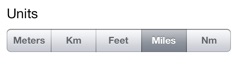
Measure in Meters, Kilometers, Feet, Miles and Nautical Miles. Easily switch between units.
Distance and Bearing
Touch a pin and you see the distance and compass bearing to either your location or to another pin.
Calipex measures distances, bearings, and areas on maps.
Calipex does this by providing you with the information you are likely to need as you drop pins on a map, which is much easier than selecting measuring tools from complex menus. Calipex uses contextual cues to determine what kind of measurement you are making.
Calipex is very useful for navigation because it gives you direction, or bearing, as well as distances and areas, something which is commonly neglected in map measurement apps.
Press an d hold a location on the map to drop your first pin. You will see information about that location in a box above the pin. Whenever you want to get information about a pin, or a line, or a shape, just touch one of the pins that makes up the object, and a similar box will appear.
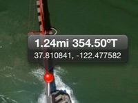
When you drop one pin, Calipex gives you the distance and bearing in degrees from that pin to your current location, along with the latitude and longitude of the pin.
If you drop a second pin, Calipex gives you the distance between the pins and the bearing in degrees along the line between them, as well as the latitude and longitude of each pin.
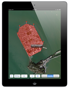
If you drop a third pin, Calipex highlights the area between the pins and calculates that area using accurate Great Circle methods, and it gives you the latitude and longitude of each pin.
As you drop more pins to outline irregular shapes, Calipex highlights the shape and calculates the area enclosed by it. You may drop as many pins as you want if you need to outline an irregular shape accurately.
Calipex lets you move pins at will without having to select them first--just touch and drag! Your measurements will be updated immediately. If you make a mistake, just hit undo, left spin icon to remove your last pin, or hit reset, Trash Icon, to start again.
Calipex lets you select the units for your measurements in feet and metres, as well as miles, kilometres and nautical miles. Area measurements are given in the associated square units.
Once you have made your measurements, you can export your work to a Keyhole Markup Language (.kml) file for use in Google Earth or another app, or you can send it by email.
There are two caveats when you are measuring irregular shapes:
1. You have to drop pins clockwise or counterclockwise to outline the shape--it doesn't matter which, but you have to pick one. Calipex numbers each pin, so you can easily drag them to their proper positions if you mess up.
2. You cannot measure a shape that includes either the North or the South Pole. Arctic explorers be warned!
Calipex runs on iPhones, iPods and iPads as a universal application.
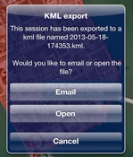
KML Export
Export your work to a KML file for use in Google Earth or other software. You can open the file right from Caliprex or email it.