Sail Tools App


Sail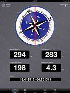 Tools collects a variety of instruments of interest to sailors and boaters into a single app. These instruments are:
Dashboard - provides a compass showing magnetic and true bearings, boat course (COG) and speed (SOG), and position latitude and longitude in a large, easy-to-read display. The compass is compensated for tilt, so you can mount your device vertically for easy viewing and still maintain accurate readings, and it is filtered to dampen the effects of sudden acceleration, giving you a steady reading in rough seas.
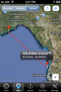
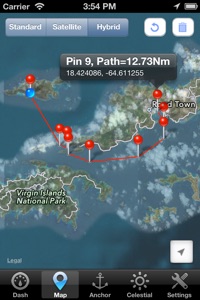
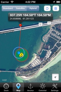
Map - displays the location of your anchor and the size of your anchor alarm zone, which is outlined in red if the alarm is set. You can also measure distances, bearings, and multi-segment path lengths directly on the map by dropping pins. Sail Tools uses contextual clues to determine what kind of measurement you are making, so that you do not have to make complicated selections from a menu before making measurements.
Position Report - send an email with your position latitude and longitude, along with your course and speed and links to your location on Google Maps and Bing Maps. You can edit the email before you send it to include a personal message, or to specify multiple recipients.
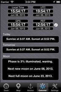
Celestial - displays sunrise and sunset times for today and tomorrow, along with the phase of the moon and the dates of the next new and full moons. Sail Tools also displays your local time and date, along with the time and date in UTC, time and date from your GPS, and from a user-settable time zone, so you can easily check what time it is back home.
Sail Tools allows you to choose between m/s, km/h, mph and knots for your speed, between m, km, feet, miles and nautical miles for distance, and between metres and feet for your anchor alarm.