Triangulex App


Take a Bearing
Point your phone using the zoomable camera view with reticle.
Compass values are tilt compensated to increase accuracy.
Intersections
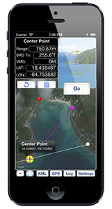
Find the intersection of your bearings and let the app find the center of multiple bearings.
Email and Export Your Bearings and Intersections
Email your findings or export as a KML file for Use in Google Earth.
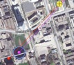
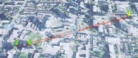
Once two sightings of the same object have been taken, Triangulex plots the points of intersection of the bearing lines on the map and provides the position, distance and direction to the object. Triangulex also displays the component of the user's speed toward or away from the object.
If the user takes more than two sightings of the object, Triangulex solves all of the triangles arising from the bearings and plots the points of intersection, along with a geographic centre point.

Other features include the ability to zoom the view through the reticle or the map display by tapping or two-finger pinch, a full-screen and rotating map display, a comprehensive data log, export to Keyhole Markup Language (.kml) for use in Google Earth or another geodetic application, a live readout of the device's location data including current bearings in degrees magnetic, true and movement-compensated, and buttons to undo the last sighting or reset all.
Use of location services and a data connection increase the power consumption of the device. Triangulex should be used with a charging adapter when possible and users should plan for increased power consumption while using  Triangulex.
Local strong magnetic fields and ferromagnetic objects may influence the magnetic compass. The device auto-compensates for some of these influences, but it may take a few minutes for this to occur when the device is moved to a new area. Turning the device in a 360-degree arc before making measurements may help to improve the accuracy of sightings.
Navigators must rely upon all available information when making decisions and should not rely upon the data provided by this application for any purpose.
Triangulex is a universal app